The Beginnings of a French Colony
By Sophie DrouinThe French were disheartened by the challenge of establishing a settlement on the Atlantic coast. Interested in the resources located inland, they quickly recognized the advantages of a location in the interior of the continent. For them, it was a matter of reconnecting with the adventures of Cartier and Roberval. Since the turn of the century, a seasonal trading post had been created on the principal route to the interior, at Tadoussac. Then, in July 1608, a settlement was established at Quebec. In 1629, the process was just getting underway and success was precarious when the settlement, which only had a small number of inhabitants, was captured by the English. However, Quebec and New France were soon returned to the French. Quebec was more firmly established under the monopoly of the Cent-Associés who oversaw the first veritable efforts at colonization, even if they only achieved some the goals set out by the city’s founder, Samuel de Champlain.1
The Trading Post and the Fort
Who Was Champlain?
Little is known about Samuel de Champlain. Born around 1570 in Brouage, a Huguenot city in the Saintonge region, Champlain died at Quebec on 25 December 1635. Since some of the registers in his birth parish were lost to fire, it is not known whether the man who became the apostle of Roman Catholicism in New France had previously been a Protestant, as his given name would suggest. He married Hélène Boullé in 1610, when he was about 40 and his bride was 12 years old. The marriage contract stated that he was the son “of the late Anthoine de Champlain, formerly a captain in the Navy, and of Lady Marguerite Le Roy.” Champlain’s wife visited America only once, between 1620 and 1624. They do not appear to have had any children. The legitimacy of Champlain’s noble titles has also been put into question, as the letters patent which could confirm them have never been located. Did he really join the nobility? If so, when?

Figure 1Champlain’s Map of 1632 (detail)
Les voyages de la Nouvelle-France occidentale, dicte Canada, Paris, Collet, 1632, Bibliothèque nationale de France, ANC/CNCP-15661. GE C-6108 (RES).
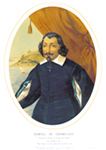
Figure 2 Portrait of Samuel de Champlain
Ducornet, BANQ-Québec, P600, S5PLC43.
What is known for sure is that when he was posted to New France, Champlain had to fill various functions. His writings include several relations or memoirs which have been gathered together in multiple volumes and which contain rich descriptions and frequent personal comments. Reading these works allows for an appreciation of the many facets of the man.
As a geographer, he described the landscapes of the new colony as his explorations progressed. As an ethnographer, he attempted to describe the lifestyle and customs of the Indigenous peoples, achieving limited success. As a lieutenant and a commander in the new colony, he described his difficult relations with the merchants. As a cartographer, Champlain was the first to establish the boundaries of New France and the coast of what would become New England. And he did so with remarkable precision, given the instruments he had at his disposal. Champlain was also an accomplished artist, and his writings were decorated with maps and engravings copied from his own drawings. Like the Jesuit Relations or the Grand Voyage of Frère Sagard, Champlain’s writings constitute an indispensable resource for anyone interested in the beginnings of New France.
When his explorations began, Champlain was working on behalf of a group of merchants formed by Aymar de Chaste. He held neither an official title nor any authority. But he was definitely working as a geographer and intended to make a report to the king. As time went on, he played an increasingly important role in colonial affairs. In 1608, the year Quebec was founded, Pierre Dugua de Mons, who had succeeded Chaste, designated Champlain as his lieutenant. From that moment onward, Champlain would not stop promoting his ideas concerning New France. He sought the establishment of a veritable colony, even if the merchants were satisfied with mere trading posts. Tensions flared periodically and Champlain crossed the Atlantic some twenty times between 1603 and 1635 in order to defend his projects at court. In December 1635, he died from complications arising from an illness which had paralysed him a month earlier. Champlain was buried, according to his wishes, in a vault of the Notre-Dame-de-la-Recouvrance Chapel. After the small church burned a few years later, his remains were relocated and, to this day, archeologists are still searching for his final resting place.
Quebec City cherishes the memory of Champlain’s life and acts by using his illustrious name to designate a neighbourhood, roads and monuments. However, it was not until the 19th century that historians recognized Champlain as the founder of the city and the father of New France. In fact, he could just as well claim the title of founder of Canada.
From Habitation to Fort
Upon landing at Quebec, Champlain immediately constructed a groups of buildings, known as the habitation, near the present-day Place Royale.
I immediately charged a portion of our labourers with felling trees for our habitation, another with sawing logs, another with digging the basement and building the foundations, and another with fetching commodities at Tadoussac in the boat. The first thing we had made was the storehouse to protect our supplies, which was promptly done with diligence by each and which I received […].
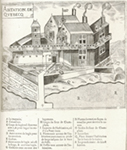
Figure 3The “Abitation” according to a drawing by Champlain
Samuel de Champlain, BANQ-Québec, 0002663498.
The dictionary of the Académie française from 1694 defines an “abitation” as “a newly-built establishment in a distant country, & which had not be inhabited before.” This first buildings served as lodgings, a site of commercial exchange and a defensive position. In reality, for a period of 20 years the entire life of the colony was centred on this location. Champlain described the habitation as follows:
I ordered an expansion of our lodgings, which had three main buildings of two stories each. Each was three toises [about 6 m] long and two and a half [5 m] wide: the storehouse, six and three wide, with a nice basement six feet tall. All around our lodgings, I had a veranda constructed outside on the second floor, which was highly convenient, with 15 foot wide ditches and six deep; and beyond the ditches, I had placed several bastions which enclosed a portion of the lodgings, where we placed our canons; and, in front of the building, there is a public square four toises wide, and six or seven long which lay along the shore of the river. Around the lodgings, there are gardens which are very good and a public square, on the north side, which is a hundred or six-score steps long, 50 or 60 wide.
The habitation built by the French evoked a medieval fortress with its palisades, its moats and its draw-bridge. In reality, this building already brought together several functions of the future city. It was where decisions were made, tasks were assigned and work coordinated for the new colony. However, the dominant activity long remained the fur trade.
In 1620, Champlain decided to erect a wooden fort on the promontory just above the habitation, as well as a residence “to avoid the dangers which could come about, given that without it there is no security in a country far from almost any help.” Thus was born the Château Saint-Louis. At the chosen spot, the mountain provided a commanding view of the St. Lawrence, which offered obvious defensive advantages. The first fort built at Quebec would ultimately prove inadequate, but its construction confirmed the symbolic importance of the location with regard to defence.

Figure 4Defeat of the Iroquois at Lake Champlain
LAC, 1613, C-5750.
As for the original habitation, hastily constructed with green lumber and repaired on many occasions, it was replaced by a new one between 1624 and 1626. In the second habitation, commercial activity played a larger role, since several residences had already been established nearby.
With the fort on the hill and the habitation below, the new trading post already boasted two distinct sectors. The habitation and the fort represented the two principal functions, commercial and military, for the coming centuries.
The Capture of Quebec by the Kirke Brothers
In the spring of 1628, the residents of Quebec impatiently waited for the arrival of the vessels carrying provisions, but they were nowhere to be seen. Finally, in July, a ship did visit the settlement. The population learned that the English, under the command of David Kirke, had intercepted all of the French vessels and that they controlled access to the St. Lawrence. Kirke and his brothers summoned the leader of the young colony. Champlain responded with a bluff, by giving the impression that his positions were much better defended than they were in reality. The ruse was effective but, the next year, David Kirke was back. The French were on the verge of famine and were completely spent. Champlain was thus forced to withdraw and the fort fell to the English. The latter would remain until 1632, when the Treaty of Saint-Germain-en-Laye returned the St. Lawrence Valley to France.

Figure 5Growth of Our Empire beyond the seas
: our first footing in Canada, Champlain surrendering Quebec to Admiral Kirke,
July 20 1629
Raphael Tuck & Sons, BANQ–Rosemont-La-Petite-Patrie, CP 037633 CON.
Quebec City and Champlain’s Vision
Almost ten years had passed since the founding of Quebec. In the meantime, Champlain had acquired, through explorations and thanks to the commercial connections which he had developed with several First Nations, a better knowledge of New France. He had a good idea of the possibilities for development in the young colony, which nevertheless remained stagnant in terms of population.
At the beginning of 1618, Champlain submitted two reports, one to King Louis XIII and the other to the Chamber of Commerce, reports which sought to convince them of the well-founded and profitable nature of a permanent commercial establishment in New France. He proposed nothing less than a colony of settlement, supported by commerce, mines, fisheries, agriculture and a few industries whose contributions to the kingdom were listed as follows:
|
Resources |
Annual Revenues (in pounds) |
|
Fisheries |
1 000 000 to 2 000 000 |
|
Finished Lumber |
400 000 |
|
Wood By-Products |
500 000 |
|
Mining |
1 000 000 |
|
Hemp |
300 000 |
|
Fabric and Rope |
400 000 |
|
Furs |
400 000 |
|
Agricultural Products |
400 000 |
As part of this program, Champlain recognized the role of the fur trade, but he did not make it the cornerstone of colonial development. He envisaged diversified economic activities, which would be supported by the exploitation of natural resources. For example, the lumber of New France was of good enough quality for naval and furniture construction. The vessels constructed on site could also serve to transport various products to the mother country. As for agriculture, its primary role would be to support the colony and allow the latter to free itself from its dependence on France for food.
The commercial component, though significant, mainly sought to support settlement, which was the primary concern of Champlain. Up until then, the population of New France was principally composed of merchants, workers and clergy. The majority of them returned to France at the end of their contracts or engagements. To encourage settlement, Champlain sought to attract entire families by offering them conditions of settlement that would encourage their permanent residence in the country.
The territory to be settled was vast: Champlain’s vision encompassed the entire St. Lawrence Valley. In addition to settlement in the countryside, he foresaw the creation of four cities: on the existing sites of Tadoussac and Quebec; at Trois-Rivières, a site which had attracted his attention since 1603; and at Montreal, where he sought to create a settlement with the agreement of the local First Nations. In this context, the site of Quebec would be called on to play a leadership role: a city almost the size of St. Denis, which will be called, God willing and if it pleases the king, LUDOVICA. Champlain hoped to established this city in the valley of the St. Charles River. And if he proposed to name the future city in honour of the king, it has to be the capital of the colony.
The vast territory also had to be defended and organized. Three forts with garrisons – one at Cap Diamant, the second at Pointe Lévy and another at Tadoussac – would command the St. Lawrence, the entryway to the colony. And in order to support the administrative and judicial organization of the territory, a Council would be established to put into operation the fundamental laws of the state and to which all trials and procedures would be submitted, though without recourse to prosecutors or lawyers.
Finally, the new colony would facilitate the pursuit of an important objective of the French crown by supporting the spread of Christianity in two ways. First, by establishing a Catholic population, the king would extend the territory dominated by the Christian faith. Second, by converting the Indigenous peoples, France would provide new souls to the Church.
Champlain gave himself 15 years to complete his program. By then, the colony would be well established and would no longer require the support of France. The program received the support of the king, but little was accomplished. One of the most striking results was the creation in 1627 of the Compagnie des Cent-Associés. Founded by Richelieu, the Cent-Associés had the responsibility for implementing Champlain’s vision.

Figure 6Cardinal-Duc de Richelieu
Philippe de Champaigne, The National Gallery, London, NG1449.
In 1628, a contingent estimated to contain about a hundred individuals set sail for New France. Unfortunately, the Kirke brothers intervened and intercepted them, which delayed the efforts of the company until 1632. The second contingent was much more modest in size (about 40 individuals). In the following years, the company would never succeed in attracting groups as large as it did for its first attempt.
As for “Ludovica,” it was never built. Champlain nevertheless succeeded in achieving certain elements of his program which would greatly influence the destiny of Quebec. The fort, constructed in 1620, provided Quebec with solid defences. Administrative, judicial and religious power was also concentrated at Quebec. These different functions, which would be progressively better defined over the years, thus rapidly took their place on the Quebec landscape.
Establishing the City
When the French, who numbered about forty, returned to Quebec in 1632, they discovered that almost all of the buildings had been wrecked. The second habitation of 1624 had been burned, as well as the adjacent Recollet chapel, erected in 1615. The Jesuit residence, situated on the north shore of the St. Charles River in Notre-Dame-des-Anges, and where English soldiers had been housed, was in a very bad state. It consisted of a wooden house measuring 40 by 23 feet, divided into four rooms, one of which served as a chapel. The Recollet convent, then situated on the site of the present-day General Hospital, was also significantly damaged. This establishment included a two-story stone house, measuring 34 by 22 feet, a chapel, gardens and a barn with equipment, all in an area enclosed by a wooden palisade with bastions in the four corners. Briefly occupied by the Jesuits upon their return, the convent would remain abandoned until 1670, the year when the Recollets returned to the colony.
On the promontory, the Fort Saint-Louis was still standing. The property of the Hébert-Couillard family, who had remained in the country during the occupation, was in good shape. The only farm in the colony, it included a stone house, another building containing a brewery, three main buildings, including one which had a chimney and two others which served as a barn and stable, a watermill, a lime kiln and a cistern. The lands were being cultivated and there was also a small apple orchard.
Repairing the Damage
The major work of reconstruction and redevelopment began in 1633, with the return of Champlain and the arrival of reinforcements – about 200 people, including a large number of labourers. The habitation was reconstructed first, and would henceforth serve as a storehouse, an essential premises for trade and the subsistence of those who remained over the winter. Indeed, the storehouse was the only place where the colonists could obtain necessities, the Cent-Associés having a monopoly over trade. This completely renovated building was 78 feet long, 22 feet wide and between 12 and 13 feet tall, and was flanked by two turrets. The Fort Saint-Louis, while maintaining its defensive function, henceforth replaced the habitation as the administrative centre. The commander resided there. A chapel was also added to the fort, where the Jesuits officiated. The Jesuits repaired their Notre-Dame-des-Anges convent and surrounded it with a palisade, in order to better defend their property. During the same years, they also build a flour mill on the shore of the river.
Given that the population had increased to more than 200, the small chapel of the Fort Saint-Louis proved too cramped. There was also a chapel at the Notre-Dame-des-Anges convent, but it was also too small and not centrally located. In the fall of 1633, Champlain therefore ordered that a new chapel be built and paid for by the Cent-Associés between the fort and the Hébert-Couillard house. It would be built of fir and measure 40 by 16 feet. It would have no transept and would include a west-facing entrance. According to the annals of the Hôtel-Dieu, Notre-Dame-de-la-Recouvrance “was quite pretty: the arch and the baluster gave it an air of neatness which made it quite gay.” In 1635, a rectory was built near the chapel to serve the needs of the priests responsible for officiating masses who had previously lived at the fort. Soon, classes were offered there for French children. Thus, upon the death of Champlain in 1635, the post established at Quebec was entering a new phase of development.
Montmagny’s Plan
In 1636, Charles Huault de Montmagny arrived at Quebec as the new governor. He was the first to hold the title, as Champlain had been commander of New France in place of Richelieu. Named by the Compagnie des Cent-Associés, Montmagny was charged with founding a city.
As opposed to Champlain, who had identified locations in the St. Charles Valley, Montmagny chose to establish the city on the hill, thereby consolidating the already-existing settlement. Concerned with improving defence, he had a plan prepared for a fortress which was to be constructed of stone and brick. The construction of the new Château Saint-Louis would continue until 1648.
Since he wanted to establish the city on the eastern side of the Quebec promontory, Montmagny had to repossess certain lands already granted to the Hébert-Couillard family and to the religious communities. Between 1636 and 1645, he therefore arranged exchanges, notably offering the lands surveyed by Champlain for his Ludovica project. The Hébert-Couillards surrendered 42 of their 100 acres on the hill in exchange for 52 acres on the right bank of the St. Charles River. The Jesuits, the Ursulines and the Hospitaliers surrendered half of their respective concessions in the Upper Town, but they were generously compensated with grants of other lands. In 1641, about 59 acres were repossessed in the area of the Fort Saint-Louis. The governor could henceforth proceed with the distribution of building lots. However, he would have to wait until 1647 before any inhabitants settled, the policy of Montmagny being to grant only lots in roture within the limits of the city. The governor also refused to grant fiefs close to the city, being careful to reserve an area for suburbs.
Montmagny also established the layout of the city to ensure that future construction would be well-ordered. In doing so, he drew the first major arteries, including the chemin Saint-Louis or “grand chemin du cap Rouge.” The layout of the Upper Town, adapted to the form of the Quebec promontory, would henceforth take the form of a fan, spreading out from the point where the Fort Saint-Louis was located, the Place d’Armes and the outlets of the hill leading to the Lower Town. The result bore witness to obvious military and urbanistic concerns.
Below, the Lower Town continued to develop according to the elements already in place. A few streets soon framed this narrow band of land, suggesting the beginnings of a plan. Here, the criteria of military urbanism were much less evident. The wharf, property of the company, was principally used as a port and a workplace for its agents. During his mandate, Montmagny rarely intervened in the development of the wharf, granting only one piece of land to the Jesuits for the construction of a warehouse.
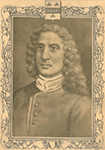
Figure 7Charles Huault de Montmagny circa 1800
Archives de la Ville de Montréal, CA M001 BM001-05-P1516.
The Compagnie des Cent-Associés and the Communauté des Habitants
Until 1663, the French king had little involvement in the colonization and development of New France. He preferred to give the responsibility to merchant companies which nevertheless showed themselves to be more eager to profit from their fishing and fur trading rights than to fulfil their obligations with regard to settlement and the improvement of lands under their jurisdiction.
Inspired by the program proposed by Champlain in 1618, in 1627 Richelieu founded the Compagnie des Cent-Associés, also called the Compagnie de la Nouvelle-France, whose 120 shareholders each invested 1000 pounds in the company. In return for is commercial privileges, the Compagnie des Cent-Associés had to promote the evangelization of the Indigenous peoples and encourage the development of the colony, notably by attracting 300 colonists per year over 15 years. It was an ambitious program, which quickly faced the difficult conditions surrounding settlement in the New World.
In 1645, the Compagnie des Cent-Associés surrendered its trade monopoly to the Communauté des Habitants which, in exchange for its privileges, had to fulfil various obligations: pay the salary and expenses of the governor and his lieutenant, the captains, officers and soldiers; provide the forts with munitions and maintain them; provide for the clergy; ensure the transportation of provisions and supplies to religious communities; settle 20 persons (or six families) each year; provide free transportation to the two agents of the Compagnie des Cent-Associés; assume the debt of the Cent-Associés; pay 1000 pounds of beaver annually to the Cent-Associés in seigneurial rights. The first years were prosperous. However, internal tensions, the weight of economic obligations, unfavourable borrowing terms and war with the Iroquois doomed the efforts of the Communauté.
In 1663, Louis XIV made New France a royal province. He dissolved the Compagnie des Cent-Associés, which brought about the disappearance of the Communauté des Habitants the following year. He granted New France to the Compagnie des Indes occidentales, which itself also eventually disappeared, leaving responsibility for the colony solely in the hands of the king, with the assistance of the colonial administration. Despite the critical judgement often passed on the performance of the Cent-Associés, it must be admitted that they nevertheless laid the foundations for long-term settlement. Aside from maintaining a small but regular flow of immigrants, they put in place the basic structures of the Quebec countryside, by dividing lands into seigneuries and by granting them to seigneurs who had the responsibility for development. They also introduced institutions destined to regulate economic and social life. Above all, they affirmed the French presence in America and made Quebec France’s capital in the New World.
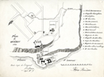
Figure 8Map of Quebec City in 1640
P. L. Morin; Johan Bourdon, Archives de la Ville de Montréal, CA M001 BM002-39-D015-P018.
An Emerging City
In 1633, the population of Quebec was about 70, or comparable to what it had been in 1627. However, once the Compagnie des Cent-Associés took responsibility for the colony, there was a period of demographic growth during which new colonists regularly arrived, at a rate of up to 300 per year. Most of these new arrivals preferred to establish themselves in the surrounding countryside. In a colony whose economy was still precarious, land ownership appeared advantageous. It ensured food for the family and allowed for the sale of surplus produce and the development of an inheritance.
As a result, by 1645 the region surrounding Quebec had a larger population than the town itself. In areas where the Iroquois were still a threat, there was little settlement in the countryside. At the time, the Quebec region had a population of about 600, which represented two-thirds of the colony’s total population. The town itself had barely a hundred inhabitants, who were mainly company agents, soldiers attached to the fort, members of religious communities and members of the governor’s entourage. There were health services available, as well as educational opportunities offered by the Jesuits. Already laid out according to a plan and home to several institutions, Quebec remained a town that was yet to develop into a city. For lack of population, it was slow to develop and conserved the characteristics of a trading post. The residents were mainly employed in the trade and storage of furs, in supporting religious missions and in welcoming immigrants.
Single men and a few families, members of religious communities, enlisted men, labourers and domestic servants: they all landed at the port of Quebec. One example was Jean Bourdon, an unmarried man who would soon be called on to play the important role of engineer and surveyor. He arrived in 1634. The first representatives of the Ursuline order and of the Augustine Hospitaliers landed in 1639.
The new arrivals were drawn from a range of social contexts: clergy, nobles, bourgeois and commoners. However, the population was not balanced in terms of gender, being about 80 % male – a situation which was not so exceptional in a new colony. The first tasks of the new arrivals were to build a home, to begin to clear the land, and to undertake the initial ploughing, seeding and harvest. When conditions finally became more favourable, some sent for their wives and children.
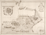
Figure 9Map of the Fort Saint-Louis, 1683
Jean Baptiste Louis Franquelin, Bibliothèque nationale de France - Archives nationales d’outre-mer, FR ANOM 03DFC347B.
Around 1645, Quebec began to flourish. Several major projects were initiated, especially in the Upper Town. Since 1642, the Augustine Hospitaliers had been constructing a monastery, which was completed in 1646. Between 1654 and 1658, they enlarged their facilities by building a sickroom which would later become the Hôtel-Dieu Hospital. In 1647, the Jesuits began building a college and a church. Work was undertaken to complete the bastion of the Fort Saint-Louis, where the construction of the new chateau was finally begun, a stone edifice measuring 86 feet by 24 feet. The great storehouse, a stone building measuring 80 feet by 24 feet which had fallen into disrepair, was refurbished in 1648. In 1651, the Ursulines rebuilt their convent, which had originally been constructed in 1641 but which had burned down a year earlier. The parish church, destroyed by fire in 1640, was rebuilt beginning in 1647 on a lot located a bit further north and donated by Guillaume Couillard. Around 1650, aside from the lodgings and storehouses of the Jesuits, the Lower Town included three other storehouses, a blacksmith’s shop and two houses. The Ursulines also built a warehouse in 1658.
Meanwhile, with the arrival of new immigrants, the concession of lots began and development accelerated. Houses, warehouses and outbuildings were built with lumber, stone and half-timber. Between 1647 and 1662, 80 acres were granted for lots in the Upper Town and 9.7 acres in the Lower Town. The year 1655 represented a high point for both the Upper and Lower Towns, with 25.3 and 5.3 acres granted respectively. The Upper Town remained dominated by large institutional blocks. Their owners preferred the high plains to the surrounding hills, which made for rather chaotic urban development. The Lower Town emerged as the business district, as well as being the main residential neighbourhood. The observations of the Jesuit Paul Ragueneau provide evidence of uneven growth and specialized neighbourhoods: he counted some 30 houses in 1650 and 66 in 1663, including 50 in the Lower Town.
In 1663, at the dawn of the royal government, the settlement at Quebec had 550 inhabitants. The town was markedly more diversified as evidenced in the occupations of the population. To the members of the clergy and the administrators were added merchants, mariners and builders. There were also numerous artisans producing clothing, food and tools. Enlisted men and domestic servants were numerous, making up about 18 % of the population. As for the surrounding countryside, it now had 1400 inhabitants, of whom almost a third also owned property in the city. Of the colony’s 3000 residents, two-thirds had chosen to live in Quebec or the surrounding area.
Notes
BIBLIOGRAPHY
- Click here for the full bibliography of Québec, ville et capitale.
All rights reserved. Centre interuniversitaire d’études québécoises (CIEQ)
Legal Deposit (Quebec and Canada), Q1 2023.
ISBN 978-2-921926-84-3 (PDF)
Credits
- TRANSLATION – Steven Watt
- Graphic design – Émilie Lapierre Pintal in collaboration with Marie-Claude Rouleau (Élan création)
- Coordination – Sophie Marineau
- Programming – Adam Lemire with the collaboration of Tomy Grenier and Jean-François Hardy
How to cite this paper
DROUIN, Sophie. 2023. The Beginnings of a French Colony. Québec: Les Presses de l'Université Laval (“Atlas historique du Québec” series). [Online]: https://atlas.cieq.ca/historical-atlas/interactif/the-beginnings-of-a-french-colony.html (accessed February 25, 2026).